Politics & Government
Graphic: Trails, Campgrounds and Picnic Areas to be Reopened in the Angeles National Forest
Here is a guide to some of the key areas that will be closed and open starting on Monday.


As we reported on Monday, the U.S. Forest Service is opening more than 98,000 acres of the Angeles National Forest on Monday in areas that were destroyed by the Station Fire. That will include more than 100 miles of trails, and several picnic areas and campgrounds.
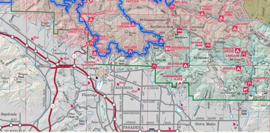
The above maps illustrate what will be open and what won't be. Basically, everything bounded within the blue line will be closed and everything else will be open. As you can see, that means some of the closures in the trails above Altadena will remain in place, while some will be lifted.
A full map with zoom functions on the Forest Service website will allow trail users to get very detailed looks at their favorite areas to determine whether they will be opened or not.
Find out what's happening in Sierra Madrewith free, real-time updates from Patch.
The most open areas will be in the eastern side of the mountains, where some of the higher elevation areas were spared from the fire, and some were kept more under control. The west areas, near Big Tujunga Canyon, are almost entirely closed.
Below is a breakdown of some of the areas closest to Altadena:
Find out what's happening in Sierra Madrewith free, real-time updates from Patch.
- Arroyo Seco area: The trails above JPL at the trailhead at Windsor and Ventura have mostly been closed since 2009. A lot will now be opened. The Upper Arroyo or Gabrielino trail will be opened for several miles above JPL up to the Paul Little Picnic Area. The Gould Mesa Campground will also be reopened. At that point the trail will be closed up to its intersection with Bear Canyon trail. In addition, the lower El Prieto Canyon trail will be closed up until the intersection with the Brown Mountain road, a popular mountain biking area. The Brown Mountain trail/road will remain closed.
- Millard Canyon: The campground at Millard Canyon is already reopened, and the fire road to Mt. Lowe has also stayed open. The Sunset Ridge trail will now also be reopened.
- Switzer's Canyon/Picnic Area: This popular picnic area is accessed by Highway 2, but hikers and mountain bikers also could previously connect from this area to JPL via the Upper Arroyo/Gabrielino trail. That segment is not entirely open yet, however. The section from Switzer's Canyon to its intersection with Bear Canyon trail will be opened, but the section from Bear Canyon to the Paul Little Picnic Area will remain closed, as mentioned above.
Below, here is a short status recap of which trails or campgrounds will be opened next week in the Altadena area:
- Upper Arroyo/Gabrielino - open, but only up to Paul Little Picnic Area, or down from Switzer's Canyon to the intersection with Bear Canyon trail.
- El Prieto Canyon - open, but only to the intersection with Brown Mountain Road.
- Brown Mountain Road - closed
- Sunset Ridge Trail - open
Get more local news delivered straight to your inbox. Sign up for free Patch newsletters and alerts.